Porirua's coastal basin sits on a mix of soft alluvial deposits and weathered greywacke, creating sharp lateral contrasts in stiffness that standard borehole logs often miss. The harbour edge and reclaimed areas near the CBD amplify these variations, making a uniform site class assumption risky. A MASW survey captures the shear wave velocity profile continuously across the site, delivering the VS30 value required under NZS 1170.5:2004 for seismic site classification. Where deep soft sediments extend beyond 30 metres, we pair the surface wave data with seismic refraction to constrain the bedrock depth and velocity inversion zones. The result is a defensible site class — B, C, or D — backed by measured data rather than default assumptions.
A measured VS30 from MASW removes the N-value uncertainty that plagues Porirua's interbedded harbour sediments.
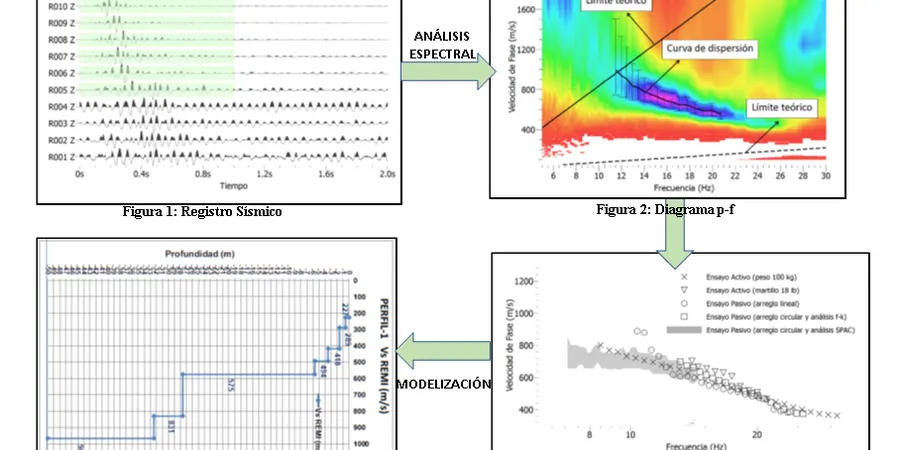
Methodology and scope
Local considerations
A three-storey apartment block on the alluvial flats south of the city centre was originally classed as Site C based on a single borehole log. The structural design proceeded with a ductility factor calibrated to that assumption. A subsequent MASW survey revealed a 4-metre-thick soft silt layer at 8 metres depth that dropped the VS30 into Site D territory. The design spectra had to be revised, base shear increased, and the lateral system rechecked — all after consent had been lodged. The cost of the MASW survey was negligible compared to the rework and the liability of an incorrect site class. In Porirua's variable ground, proxy-based classification is a gamble that engineering judgement alone cannot resolve.
Applicable standards
NZS 1170.5:2004 Structural Design Actions — Earthquake Actions, NZGS Module 5: Site Investigation for Earthquake Engineering, ASTM D7400-17 Standard Test Methods for Downhole Seismic Testing (adapted for surface wave methods)
Associated technical services
VS30 Site Classification Survey
Full MASW acquisition across the building footprint with dispersion analysis, inversion, and NZS 1170.5 site class determination. Includes 1D VS profiles and mapped site period T0 for structural input.
Combined MASW + Seismic Refraction
For deep basins or sites with suspected velocity reversals — common in Porirua's buried valley systems — we run co-located MASW and refraction lines. The P-wave velocity model constrains the MASW inversion, improving VS accuracy below 20 metres.
Typical parameters
Frequently asked questions
How much does a MASW survey cost in Porirua?
A typical MASW survey for a single-family or medium-density site in Porirua ranges from NZ$2,690 to NZ$4,720, depending on the number of array positions and whether passive microtremor recording is added for deeper profiling. A fixed-price proposal is provided after reviewing the site layout and access conditions.
What is the difference between MASW and downhole seismic testing for VS30?
MASW measures surface wave dispersion along a linear array at the ground surface — it is non-invasive and provides a continuous VS profile averaged over the array length. Downhole seismic requires a borehole and measures travel times directly between a surface source and a downhole receiver. MASW is faster and covers more lateral ground for the same budget. In Porirua's interbedded soils, MASW often yields a more representative VS30 because it averages over a wider volume, reducing the influence of local gravel pockets or soft lenses that can bias a single-borehole measurement.
Can MASW work on small or sloped sites in Porirua?
Yes, within limits. The minimum array length for a 30-metre investigation is about 46 metres. On smaller lots, we can shorten the array and combine active-source MASW with passive microtremor recording to extend the depth range. Sloped sites along the Porirua hillsides require careful geophone coupling and may need a topographic correction in the inversion. We assess site geometry during the scoping visit and confirm feasibility before mobilisation.
How long does a MASW survey take and what is the deliverable?
Field acquisition for a single array takes about one hour. Most Porirua residential sites require two to three array positions, so fieldwork is completed in a morning. The processed report — including dispersion curves, inverted VS profiles, VS30 calculation, and NZS 1170.5 site classification — is delivered within five working days. The report is formatted for direct inclusion in a structural engineer's design basis memorandum.