Porirua's basin sits on deep alluvial and estuarine sediments with water tables often within 2 metres of the surface. The 2016 Kaikōura earthquake triggered minor liquefaction ejecta in parts of the CBD, confirming what geotechnical models had long predicted. A thorough soil liquefaction analysis here must account for the alternating layers of sand, silt, and soft clay that characterise the Tītahi Bay and Porirua East catchments. We run the analysis using site-specific CPT data, often supplemented by SPT drilling where gravels or cemented layers prevent cone refusal, and compare the results against the triggering curves in Boulanger & Idriss (2014). The output is not a generic hazard flag; it is a quantified estimate of settlement and lateral strain for a given design earthquake.
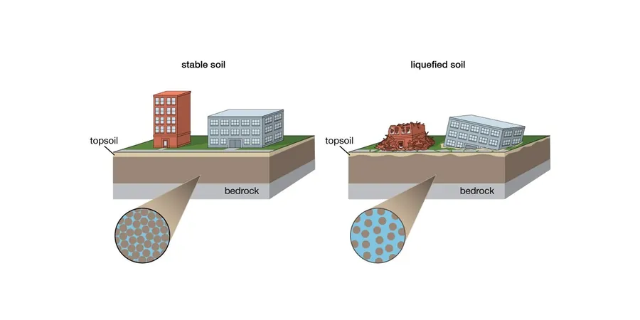
Liquefaction is not just a yes/no trigger — in Porirua it is a settlement problem that can add 50–150 mm of differential movement across a building footprint.
Methodology and scope
Local considerations
The risk profile varies sharply across Porirua. Sites near the harbour edge in Whitireia Park sit on loose, recently deposited sand with a shallow water table, giving LSN values that can exceed 15 in an ULS event. Move 400 metres inland toward the Aotea block and the underlying weathered greywacke brings the liquefaction vulnerability down to isolated pockets of alluvium. A geotechnical report that treats the whole city as one hazard zone is practically useless. We map the stratigraphy borehole by borehole, using CPT testing to capture thin liquefiable layers that a standard SPT log would miss. The differential movement across a single large site can govern foundation design more than the absolute settlement.
Applicable standards
NZGS Earthquake Geotechnical Engineering Practice Module 1 & 4 (2021), NZS 1170.5:2004 Structural design actions – Earthquake actions, Boulanger & Idriss (2014) CPT and SPT-based liquefaction triggering procedures
Associated technical services
CPT-based liquefaction screening
Continuous cone penetration testing with pore pressure measurement to capture thin liquefiable seams and compute Ic-based fines content.
SPT-based triggering with laboratory support
Borehole sampling with SPT N-values, grain-size distributions, and Atterberg limits for sites where CPT is impractical.
LSN and settlement mapping
Parametric analysis across multiple ground motions to produce site-wide LSN contours and differential settlement estimates for foundation design.
Lateral spread and slope assessment
Empirical displacement analysis for near-harbour and channel-edge sites, incorporating topographic amplification where relevant.
Typical parameters
Frequently asked questions
What does a soil liquefaction analysis for a Porirua residential section typically cost?
For a standard residential site in Porirua, a desktop screening plus a CPT-based analysis with LSN and settlement output usually falls between NZ$4,610 and NZ$6,650, depending on access, number of cone soundings, and whether supplementary laboratory testing is needed for fines content.
Does the Porirua City Council require a liquefaction assessment for a building consent?
Yes. Under the current District Plan and Building Code, sites mapped as having liquefaction susceptibility require a site-specific geotechnical investigation. The report must demonstrate compliance with NZGS guidelines and provide foundation design parameters accounting for liquefaction-induced settlement.
How deep do you typically investigate for a liquefaction study in Porirua?
We generally push CPT soundings to 20 metres or refusal. The investigation depth must capture all potentially liquefiable layers above the engineering bedrock or greywacke basement, which in the Porirua basin can vary from 10 to over 30 metres.
What is the difference between LSN and a factor of safety against liquefaction?
The factor of safety tells you whether a soil layer will trigger liquefaction at a given depth. The Liquefaction Severity Number (LSN), as defined in the NZGS framework, integrates the cumulative settlement across the entire profile and gives a single number that relates directly to expected land damage — it is the metric most Porirua insurers and council engineers look for.