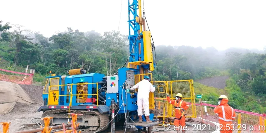
The subsurface story changes dramatically between Whitby's weathered greywacke slopes and the soft alluvial sediments underlying the Porirua city centre. On the western hills, we often encounter dense residual soils where SPT refusal can occur within the first six metres, while boreholes along the harbour fringe routinely log N-values below 10 through interbedded silts and peat layers extending past 15 metres depth. This contrast is exactly why a properly executed Standard Penetration Test matters for every project in Porirua: a foundation design that works on the Kenepuru terrace may require complete rethinking just two kilometres east. Our drilling crew operates a truck-mounted automatic trip hammer calibrated to ASTM D1586-18 energy standards, recording blow counts every 150 mm and retrieving representative split-spoon samples that feed directly into laboratory classification. For sites where refusal is reached early in dense materials, we complement the SPT with CPT testing to obtain continuous tip resistance profiles without sample disturbance, and when the investigation extends to pavement subgrades we run CBR testing on remoulded specimens prepared at target moisture contents.
An SPT N-value without energy correction is just a number. Corrected to N60 and tied to site-specific fines content, it becomes a defensible engineering parameter.
Methodology and scope
Local considerations
A four-storey apartment block planned near the Porirua Stream embankment encountered N-values of 3 to 5 across a 2.5-metre-thick layer of soft organic silt at 4 metres depth, directly below a stiffer crust of silty clay that had initially suggested competent bearing conditions. The architect had already finalised column loads when our SPT logs revealed this hidden weak zone. A shallow footing design relying on the upper crust alone would have been dangerously unconservative, risking differential settlement of 40 mm or more over the building footprint. The investigation triggered a redesign incorporating rammed aggregate piers to transfer loads through the compressible layer. In Porirua's estuarine fringe, thin soft strata can be masked by desiccated surface soils during dry summer drilling, making refusal-based termination criteria alone insufficient. Every borehole must penetrate at least three metres into material with N60 exceeding 15 before the log can be considered complete for foundation design purposes. The same rig that identifies a problem also supplies the corrected parameters needed for a practical ground improvement solution.
Applicable standards
ASTM D1586-18: Standard Test Method for Standard Penetration Test (SPT) and Split-Barrel Sampling of Soils, NZS 3404: Steel Structures Standard – seismic design provisions referencing SPT-based site classification, NZGS Module 4: Earthquake Geotechnical Engineering Practice – liquefaction assessment using corrected (N1)60cs, NCEER/NSF (Youd & Idriss 2001): Summary report on liquefaction resistance of soils
Associated technical services
SPT Borehole Drilling and Field Logging
Truck-mounted or track-mounted rig mobilisation across Porirua, including restricted-access sites in the Titahi Bay hills and harbour-side commercial zones. Each borehole includes continuous split-spoon sampling, field classification to NZGS guidelines, groundwater observation, and installation of standpipe piezometers where pore pressure monitoring is specified. We deliver field logs within 24 hours of rig demobilisation, with N-values reported raw and corrected to N60.
Liquefaction Analysis Package
For sites within Porirua's mapped liquefaction vulnerability zones, we combine the SPT dataset with laboratory index testing to produce a complete triggering and settlement analysis. The package includes fines content determination, Atterberg limits, corrected (N1)60cs profiles, cyclic resistance ratio calculation per Boulanger & Idriss (2014), and post-liquefaction volumetric strain estimates using the Zhang et al. (2002) method.
Typical parameters
Frequently asked questions
What depth do SPT boreholes typically reach in Porirua?
Borehole depth depends entirely on the subsurface conditions and the structure being investigated. For a single-storey residential footing on the Whitby hillslopes, we may terminate at 6 to 8 metres if greywacke refusal is encountered. For a multi-storey building near the harbour, boreholes often extend to 20 metres or more to penetrate soft alluvium and reach competent bearing strata. Every borehole continues until at least three consecutive SPT intervals yield N60 values above 15 in granular material or undrained shear strength exceeding 75 kPa in cohesive soils.
How much does an SPT investigation cost in Porirua?
A typical single-borehole SPT investigation in Porirua falls in the range of NZ$800 to NZ$1,130, depending on access conditions, total depth drilled, and whether piezometer installation or laboratory index testing is included. Mobilisation charges vary with distance from our yard, but most Porirua sites are within our standard service radius. We provide a fixed-price proposal after reviewing the site address and any available geotechnical desktop information.
How long does it take to get SPT results after drilling is complete?
Field borehole logs with raw N-values, groundwater observations, and soil descriptions are issued within one working day of rig demobilisation. If laboratory testing such as Atterberg limits or grain-size analysis is included in the scope, the final factual report with corrected N60 profiles and liquefaction screening is typically delivered within five to seven working days. We can accelerate turnaround for urgent foundation redesigns on request.